The Adventurer’s Sunrise Route starts in the dark on Monkey Mountain (Cerro del Mono), the hill that rises between Higuera Blanca and Sayulita in the municipality of Bahía de Banderas. You hike up by headlamp, watch first light break over the Sierra de Vallejo and the coast, come down for breakfast and spend the rest of the day on the water: a surf lesson or an Islas Marietas tour from Punta de Mita, then sunset in San Pancho. It adds up to about 40 km (25 mi) of driving, all paved.
A fair warning about what used to be here: the old version of this route proposed Sayulita, San Pancho, Mesa del Nayar and Ceboruco volcano in a single day of “about 150 km”. That cannot be done. Mesa del Nayar sits in the northern sierra and Ceboruco in the south of the state, hundreds of kilometers and many hours apart. We kept the name and the spirit (an adventure that begins at dawn) and rebuilt it in an area where every stop is less than half an hour from the next.
Why Monkey Mountain? Because the Riviera Nayarit coast faces west. Here the sun sets over the ocean but rises behind the mountains, so if you want a sunrise with the Pacific at your feet, you have to climb. Below is the hour-by-hour plan with distances, seasons and what to know about the trail.
What the Adventurer’s Sunrise Route covers
The route stays on the northern tip of the Bay of Banderas, between the Punta de Mita peninsula and Sayulita. It works the same whether you sleep in Sayulita, San Pancho, Higuera Blanca or Punta de Mita.
- Monkey Mountain (Higuera Blanca): a hike of about 7 km (4.3 mi) round trip with roughly 400 m (1,300 ft) of elevation gain, 2 to 4 hours depending on pace.
- Punta de Mita (El Anclote beach): a surf lesson on a gentle wave, or a tour to the Islas Marietas, 15–20 minutes away by boat.
- Sayulita: lunch and downtime on the beach, or at Playa Los Muertos, which is more sheltered for swimming.
- San Pancho (San Francisco): 8 km north of Sayulita, with an open beach that faces the sunset head-on.
How to get to the Adventurer’s Sunrise Route
Your gateway is Puerto Vallarta International Airport (PVR), about 40 minutes away. From Tepic or Guadalajara, take the toll road to Federal Highway 200. More details in how to get to Sayulita.
| From | To | Approx. distance | Approx. time | Road |
|---|---|---|---|---|
| Puerto Vallarta airport | Higuera Blanca | 38 km (24 mi) | 45–55 min | Federal 200 and the Punta de Mita road |
| Puerto Vallarta airport | Sayulita | 34–40 km (21–25 mi) | 45–55 min | Federal 200 |
| Tepic | Sayulita | 130 km (81 mi) | 1 h 45 min–2 h 15 min | Toll road via Compostela and Las Varas, Federal 200 |
| Guadalajara | Sayulita | approx. 265 km (165 mi) | 3 h 30 min–4 h | Highway 15D and Federal 200 |
Mind the clock: Bahía de Banderas runs on Central time (UTC-6), like Puerto Vallarta, while the rest of Nayarit is one hour behind. If you drive in from Tepic, set your alarm accordingly.
Itinerary: from Monkey Mountain to a San Pancho sunset
The times below assume a day in October or March, with sunrise around 7:00. In June the sun comes up near 6:20 and in January around 7:40, so shift the whole schedule to match your date.
| Approx. time | Leg / stop | Leg distance | Drive time | What to do |
|---|---|---|---|---|
| 5:15 | Sayulita → Higuera Blanca | 10 km | 15–20 min | Meet your guide in the village |
| 5:40–7:00 | Monkey Mountain climb | — | — | Headlamp hike; sunrise at the top |
| 7:00–8:45 | Summit and descent | — | — | Photos, views of coast and sierra, hike down in daylight |
| 9:00 | Higuera Blanca → Punta de Mita | 6 km | 10 min | Breakfast in Punta de Mita village |
| 10:00–13:30 | El Anclote beach | — | — | Surf lesson or Islas Marietas tour |
| 14:00 | Punta de Mita | — | — | Fish and seafood lunch facing the bay |
| 15:30 | Punta de Mita → Sayulita | 16 km | 25 min | Rest or swim at Playa Los Muertos |
| 18:00 | Sayulita → San Pancho | 8 km | 12–15 min | Sunset on the beach and dinner |
That is about 40 km of driving in all. Without a car, ask your guide to pick you up; the other legs are short taxi rides.
Monkey Mountain: the sunrise climb
The trail leaves from the Higuera Blanca area and climbs through dry tropical forest to a summit overlooking the coast between Litibú and Sayulita and the tip of the peninsula. Count on about 7 km round trip and some 400 m of gain, with steep stretches and loose dirt. No experience needed, but you should be reasonably fit.
Go with a local guide from Higuera Blanca, for two reasons: part of the path crosses private land where dogs roam, and it is easy to lose the way in the dark. A guide charges approx. $300–600 MXN (17–35 USD) per person in 2026, depending on group size. Plan to start about 1 h 15 min before sunrise.
Punta de Mita: surf or the Islas Marietas
Punta de Mita village and its El Anclote beach are open to everyone; Punta Mita, the private development on the point, is for guests only. El Anclote has a long, gentle wave that is ideal for learning. A 1.5- to 2-hour lesson with board costs approx. $1,000–1,600 MXN (57–90 USD) in 2026. If you already surf, ask about La Lancha.
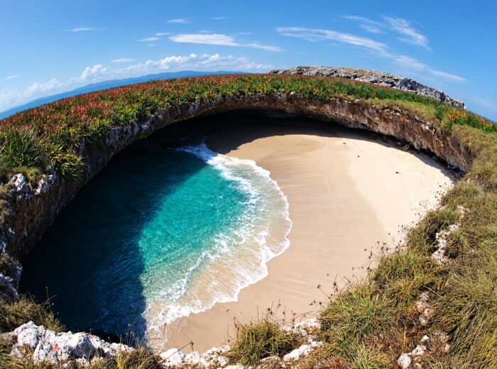
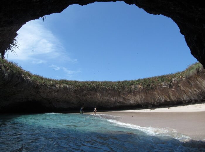
The alternative is an Islas Marietas tour. Shared tours from Punta de Mita take 3–4 hours and cost approx. $1,200–1,900 MXN (65–100 USD), plus the national park wristband. Playa del Amor (the Hidden Beach) opens Wednesday to Sunday with a daily cap; check the rules in how to visit the Islas Marietas. More on the village in our Punta de Mita travel guide.
Sayulita and San Pancho
In the afternoon, head back to Sayulita for lunch or a rest. To swim without waves, walk 15 minutes to Playa Los Muertos. For sunset, drive on to San Pancho, whose almost 2 km beach looks straight at the setting sun. The surf there is strong, so go in only with care.
Season: when to do the route
The best months are November to May: almost no rain, a dry trail and cool mornings. July to October is the rainy season. The hill turns muddy, the heat is humid and the mosquitoes are worse, so start even earlier. More in the best time to visit Nayarit.
| Month | Approx. sunrise | Approx. sunset | Seasonal bonus |
|---|---|---|---|
| January | 7:40 | 18:40 | Humpback whales in the bay |
| March | 7:10 | 19:10 | Last weeks of whale season |
| June | 6:20 | 19:45 | Heat; the longest days of the year |
| September | 6:50 | 19:05 | Rains; sea turtle releases |
| November | 7:10 | 18:20 | Dry trail, mild weather |
From December to March you can swap the surf lesson for a whale-watching tour from Punta de Mita. The official 2025-2026 season ran from December 8 to March 23. See humpback whale watching in Nayarit.
What to pack and safety
- Headlamp with spare batteries; the climb starts in the dark.
- Hiking shoes or sneakers with good grip, never sandals.
- Water: at least 1.5 liters per person for the hill.
- A light layer for the summit; it gets breezy at that hour.
- Biodegradable sunscreen and bug spray; only biodegradable sunscreen is allowed at the Marietas.
- Cash for the guide, the wristband and small eateries.
- Respect the beach flags: San Pancho and parts of Sayulita have currents.
Turning it into a weekend
With two days, do Monkey Mountain and Punta de Mita on day one and give day two to a surf session in Sayulita or other surf spots on the Nayarit coast. For more ideas nearby, read what to do in Riviera Nayarit. If you want to combine coast and mountains at a sane pace, our weekend routes in Nayarit give Mesa del Nayar and Ceboruco their own days. Find lodging in our directory.
Frequently asked questions
Where is Monkey Mountain in Sayulita?
It is in Bahía de Banderas, Nayarit, between Higuera Blanca and Sayulita, near Litibú. It is about 10 km from Sayulita and 45–55 minutes from Puerto Vallarta airport.
How long does the Monkey Mountain hike take?
About 7 km round trip with roughly 400 m of gain. The full hike takes 2 to 4 hours depending on your fitness and stops.
Do I need a guide for Monkey Mountain?
It is strongly recommended, especially at dawn. Part of the trail crosses private land and it is easy to get lost in the dark. A guide from Higuera Blanca charges approx. $300–600 MXN per person in 2026.
Can you see the sunrise over the ocean in Sayulita?
No. The coast faces west, so the sun rises behind the mountains and sets over the Pacific. That is why this route climbs the hill at dawn and ends the day on San Pancho beach.
Can I visit the Islas Marietas on the same day?
Yes. Shared tours leave from Punta de Mita, 10 minutes from Higuera Blanca, and last 3–4 hours. Playa del Amor only opens Wednesday to Sunday and has a daily cap.
What is the best time for the Adventurer’s Sunrise Route?
November to May, when the trail is dry and mornings are cool. From December to March you can add whale watching.
Area map
- 1Higuera Blanca Bahía de Banderas. Meeting point with your Monkey Mountain guide.20.79769, -105.46911 · Open in Google Maps
- 2Monkey Mountain (Cerro del Mono) Sunrise summit: 7 km round trip, about 400 m of gain.20.82201, -105.46528 · Open in Google Maps
- 3Punta de Mita (El Anclote) Surf lessons and Islas Marietas tour departures.20.77287, -105.51793 · Open in Google Maps
- 4Sayulita beach Lunch and downtime; Playa Los Muertos 15 min on foot.20.871, -105.4406 · Open in Google Maps
- 5San Pancho beach 8 km north of Sayulita; sunset over the sea.20.90436, -105.4147 · Open in Google Maps