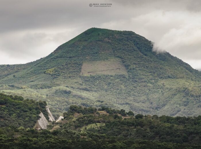
Nayarit volcanoes form the western tip of Mexico’s Trans-Mexican Volcanic Belt, and there are seven worth knowing: Ceboruco (2,280 m / 7,480 ft, the only active and monitored one), Sangangüey (2,340 m / 7,680 ft, the tallest and the peak that frames every view of Tepic), the Sierra de San Juan, Tepetiltic, Las Navajas, the small Cebadilla cone near San Blas, and the flooded crater that is now the Santa María del Oro lagoon. Almost all of them can be climbed, and you can drive right into Ceboruco’s crater.
This guide puts in one place what is usually scattered across hiking forums and geology papers: elevation and municipality for each volcano, whether it is active, how to get there from Tepic, how long the climb takes, how hard it is, the best months and where to find a guide. If you simply typed “Nayarit volcano”, the short answer is Ceboruco; if you mean the one you see from the state capital, that is Sangangüey.
Nayarit volcanoes at a glance
| Volcano | Elevation | Municipality | Type | Last activity | Can you climb it? |
|---|---|---|---|---|---|
| Ceboruco | 2,280 m (7,480 ft) | Jala | Active stratovolcano | 1870–1875 (lava and ash); fumaroles today | Yes, by car to the crater |
| Sangangüey | 2,340 m (7,680 ft) | Tepic | Eroded stratovolcano (dormant) | No confirmed historical eruptions (1742 legend on a flank cone) | Yes, on foot, 7–8 h round trip |
| Sierra de San Juan (San Juan volcano / Cerro Alto) | approx. 2,180–2,240 m | Tepic and Xalisco | Volcanic complex (state ecological reserve) | No historical activity | Yes, forest hiking |
| Tepetiltic | 2,020 m (6,630 ft) | San Pedro Lagunillas | Stratovolcano with caldera and lake | Probably extinct (over 10,000 years) | Yes, to the caldera rim |
| Las Navajas | 1,680 m (5,510 ft) | Tepic | Obsidian shield volcano | Pliocene–Pleistocene (extinct) | Yes, short hike |
| Cebadilla | 860 m (2,820 ft) | San Blas | Volcanic cone | Inactive | Yes, 2–3 h from Mecatán |
| Santa María del Oro crater | Lagoon approx. 2.5 km across | Santa María del Oro | Flooded volcanic crater | Extinct | Walk the rim, swim the lagoon |
The Trans-Mexican Volcanic Belt in two paragraphs
Mexico is crossed from west to east by the Trans-Mexican Volcanic Belt (in Spanish, Eje Neovolcánico), a band of volcanoes that runs from Nayarit to Veracruz and includes Popocatépetl, the Nevado de Colima and Pico de Orizaba. Nayarit is its western end, where the belt meets the Sierra Madre Occidental and the Pacific coast. That is why, within less than 100 km (60 miles), you find peaks above 2,000 m, crater lakes and beaches.
Of the Nayarit group, only Ceboruco has erupted in historical times. The rest appear in volcanological catalogs but are dormant or extinct structures that today serve as forests, reserves and natural lookouts. On official maps most of them are labeled “Volcán” or “Cerro” interchangeably.
Ceboruco: the active volcano you can drive into
Ceboruco (2,280 m) sits in the municipality of Jala, a Pueblo Mágico (one of Mexico’s officially designated “Magical Towns”) known for its giant corn and stone architecture. Its last major eruption began in 1870 and continued until 1875: a dacitic lava flow ran about 7 km and ash blanketed the region. Today activity is limited to steam fumaroles and small earthquakes, but Mexico’s National Center for Disaster Prevention (CENAPRED) ranks it among the country’s highest-hazard volcanoes, and the University of Guadalajara, together with state Civil Protection, keeps seismic stations on its flanks.
Getting there and the route up
- From Tepic: about 75 km (47 miles) on the Guadalajara–Tepic toll road (Mex 15D) to the Jala exit; roughly 1 hour by car.
- From Jala to the crater: a cobbled and dirt road of about 15 km climbs to the antenna site inside the crater. A regular car with good tires will make it in 1 h to 1 h 15 min; in the rainy season a pickup or SUV is wiser.
- Final walk: from the antennas to the fumarole field and crater rim is about 40 minutes on foot, across solidified lava and pine-oak forest.
Difficulty: easy if you drive, easy-to-moderate if you walk the last stretches. Best time: November to April, with clear skies and dry roads; from July to September afternoon storms often close the track. Guides: local guides at Jala’s main square offer walking or truck tours for approx. $400–800 MXN (about 20–40 USD) per group in 2026; ask at the municipal tourism office.
Sangangüey: the volcano you see from Tepic
Sangangüey (2,340 m) is Nayarit’s highest volcano and the shape on the southeastern horizon of Tepic. It is a heavily eroded stratovolcano that, over the last 300,000 years, produced some 45 cinder cones and lava flows on its slopes. There are no confirmed historical eruptions, although an indigenous tradition records activity in 1742 at one of those flank cones. The summit is a rock spire known as “la Peña”, visible from the whole city.
Where Sangangüey is and how to climb it
It rises 15–20 km (9–12 miles) southeast of downtown Tepic. The most used trails start from the ejidos (communal farmlands) on the northern slope; El Refugio is the usual trailhead, 30–40 minutes by car from the city on the road to Santa María del Oro.
- Distance and gain: 10.5–12.7 km (6.5–8 miles) round trip with 1,000–1,300 m (3,300–4,300 ft) of elevation gain, depending on the route.
- Time: 7–8 hours in total; groups leave at dawn.
- Difficulty: hard. The last 100 m to the Peña is a rock scramble where many groups use a rope; without experience, stop at the base of the spire, which already overlooks Tepic, the Sierra de San Juan and the Santa María del Oro lagoon.
- Best time: November to March. Avoid the rainy season (June–October) because of fog and mud in the ravines.
- Guides: Tepic hiking clubs run weekend climbs for approx. $300–600 MXN (15–30 USD) per person in 2026, transport from the city included. Do not go alone: there are unmarked forks on the trail.
Sierra de San Juan: the forest next to the capital
Southwest of Tepic and Xalisco rises the San Juan volcanic complex, declared a state ecological reserve in 1987 with almost 27,000 hectares (66,000 acres). Its twin summits are San Juan volcano (approx. 2,180 m) and Cerro Alto (2,240 m), the highest point of the group. The draw here is not a crater but the forest: pine, oak and a cloud forest where 345 species of land vertebrates have been recorded, more than half of all those found in the state.
- Getting there: 20–30 minutes from downtown Tepic via the Xalisco or Miramar roads; trails leave from hamlets such as El Cuarenteño and La Cuchilla.
- Route and time: 3–5 hours of hiking depending on the summit, with stretches of dense forest.
- Difficulty: moderate. Best time: October to March (in the rains the cloud forest is spectacular but slippery).
Tepetiltic: a crater with a lake
Tepetiltic (2,020 m) is in the municipality of San Pedro Lagunillas, south of Tepic. Its main feature is an elliptical caldera 5 by 2.5 km with a lake in its northeastern corner, born of a huge explosive eruption thousands of years ago; the volcano is considered extinct. Take the Guadalajara toll road (San Pedro Lagunillas exit, about 45 minutes from Tepic), then rural roads to the village of Tepetiltic, from where the caldera rim is a 2–3 hour walk. Pair it with the San Pedro and Tepetiltic lagoons for a full day.
Las Navajas: the obsidian volcano
Just north of Sangangüey lies Las Navajas (1,680 m), a Pliocene–Pleistocene shield volcano whose rhyolitic lava left large deposits of obsidian. The name means “the blades”: that black glass was knapped into knives and arrowheads from pre-Hispanic times. It is a short climb (1–2 hours) on ejido tracks northeast of Tepic, best suited to anyone interested in the region’s geology and archaeology.
Cebadilla: the little volcano of San Blas
Cebadilla volcano (860 m) is the cone that accompanies the Tepic–San Blas highway between Mecatán and Jalcocotán, in the municipality of San Blas. It is not active and appears in no hazard catalog, but it is the most photographed mountain on the way to the coast. The climb takes 2–3 hours from Mecatán through coffee groves; best from November to May.
The Santa María del Oro crater
About 50 km (31 miles) from Tepic, the Santa María del Oro lagoon fills the floor of an extinct volcanic crater: approx. 2.5 km across, 60 m deep, with water that shifts from blue to green to brown with the seasons. Nothing to climb here: you drive down to the shore, swim, paddle or walk the rim. It is the easiest Nayarit volcano to visit with children and one of the most photographed landscapes in the state; see the Santa María del Oro guide for lakeside hotels and restaurants.
Safety: is Ceboruco dangerous?
- Ceboruco is the only Nayarit volcano with seismic monitoring (University of Guadalajara and state Civil Protection) and has had a hazard map since 2019. Any change in activity would lead Civil Protection to close the Jala road; check their notices before you go.
- At the fumarole field, keep away from the cracks: the steam is hot enough to burn.
- On Sangangüey and San Juan the risk is not volcanic but alpine: fog, dehydration and getting lost. Carry 2–3 liters of water and a jacket (summit temperatures can drop below 10 °C / 50 °F in winter), and tell someone your plan.
- Official source on Mexico’s active volcanoes: CENAPRED.
Frequently asked questions
What is the volcano in Nayarit?
The best known is Ceboruco (2,280 m), in Jala, the state’s only active volcano and the only one in Mexico where you can drive into the crater. The tallest is Sangangüey (2,340 m), next to Tepic.
Where is Sangangüey?
In the municipality of Tepic, 15–20 km southeast of the Nayarit state capital. It is visible from the whole city and is climbed on foot from the ejidos on its northern slope, such as El Refugio.
Is Ceboruco active?
Yes. Its last eruption was in 1870–1875 and today it emits fumaroles and low-intensity earthquakes. CENAPRED lists it among Mexico’s higher-hazard active volcanoes, although it can be visited normally by following Civil Protection notices.
How many volcanoes are there in Nayarit?
Seven main ones: Ceboruco, Sangangüey, Sierra de San Juan, Tepetiltic, Las Navajas, Cebadilla and the Santa María del Oro crater, plus dozens of minor cones on the slopes of Sangangüey.
When is the best time to climb Nayarit’s volcanoes?
November to April: clear skies, dry trails and summit temperatures of 10–25 °C (50–77 °F). From June to October it rains every afternoon and the Ceboruco and Sangangüey tracks turn to mud.
Can you climb Ceboruco without a guide?
Yes, if you drive to the antenna site; the road from Jala is signposted. For Sangangüey and the Sierra de San Juan a guide or hiking group is advisable, because the trails have unmarked forks.
Area map
- 1Ceboruco volcano (crater) 2,280 m a.s.l. Jala. Active; last eruption 1870–1875. Drivable from Jala.21.1252, -104.5076 · Open in Google Maps
- 2Sangangüey volcano (summit) 2,340 m a.s.l. Tepic. Dormant; 7–8 h hike from El Refugio.21.4432, -104.7322 · Open in Google Maps
- 3San Juan volcano (Sierra de San Juan) Approx. 2,180 m; Cerro Alto (2,240 m) to the south. State ecological reserve, Tepic–Xalisco.21.4729, -104.9736 · Open in Google Maps
- 4Tepetiltic volcano 2,020 m a.s.l. San Pedro Lagunillas. 5 × 2.5 km caldera with a lake; extinct.21.2638, -104.6997 · Open in Google Maps
- 5Las Navajas volcano 1,680 m a.s.l. Tepic. Obsidian shield volcano; extinct.21.5319, -104.7238 · Open in Google Maps
- 6Cebadilla volcano 860 m a.s.l. San Blas. Inactive cone beside the Tepic–San Blas highway.21.5099, -105.121 · Open in Google Maps
- 7Santa María del Oro lagoon (crater) Flooded volcanic crater approx. 2.5 km across and 60 m deep.21.3694, -104.5689 · Open in Google Maps