Tepic, Nayarit: Things to Do and How to Get There
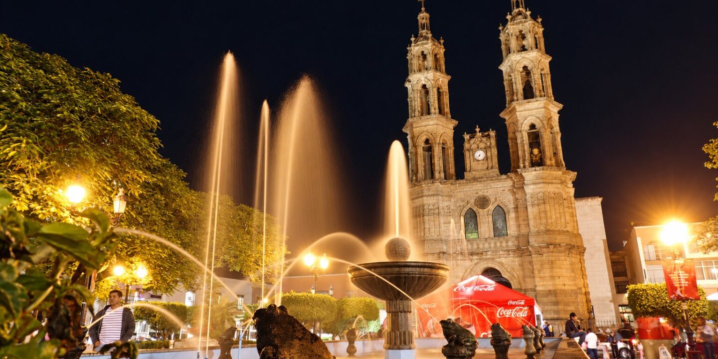
Tepic, Nayarit is the capital of the state of Nayarit on Mexico’s Pacific coast. It is the state’s largest city, with 371,387 residents in the city proper and 425,924 in the municipality (INEGI 2020 census), it sits at 915 meters (3,002 ft) above sea level, and it was founded in 1531. The city fills a valley ringed by the Sangangüey volcano and the Sierra de San Juan, halfway between Guadalajara and Mazatlán on the 15D toll highway and less than an hour from the beaches of San Blas.
This page covers everything you need to plan a visit: things to do in Tepic (historic center, museums, Loma de la Cruz, the volcano), how to get to Tepic by plane, bus or car with distances, travel times and approximate 2026 prices, what the name Tepic means, the climate by season, what to eat, and a distance table for using the capital as a base to explore Nayarit.
Tepic Nayarit at a glance: the capital of Nayarit
- State: Nayarit, on the Mexican Pacific; Tepic is the capital and seat of the state government.
- Population: 371,387 in the city and 425,924 in the municipality (INEGI, 2020 census). It is the most populous municipality in Nayarit.
- Elevation: 915 m (3,002 ft) above sea level, which gives it a cooler climate than the coast.
- Founded: 1531, by the expedition of Nuño de Guzmán. The cathedral and the historic center date from the 18th and 19th centuries.
- Time zone: Pacific time (UTC-7), one hour behind Guadalajara and Mexico City; note that the municipality of Bahía de Banderas, in the south, uses Central time like Puerto Vallarta.
- Neighboring town: Xalisco, 8 km away, forms a single urban area with Tepic.
Things to do in Tepic
Historic center
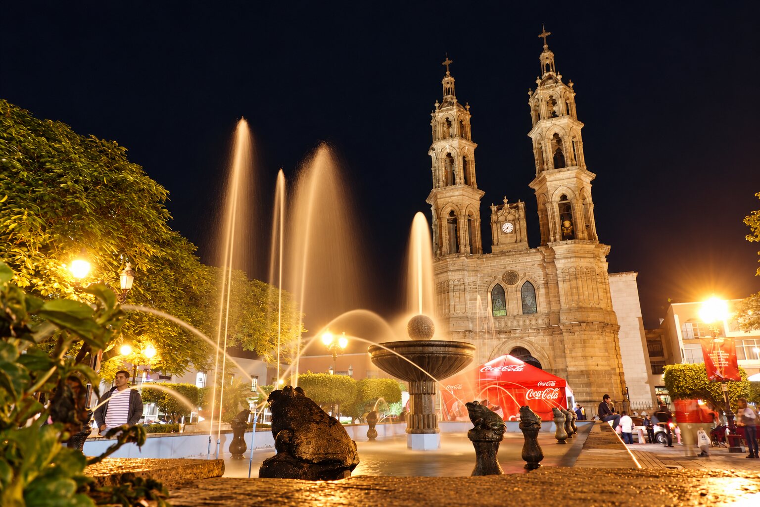
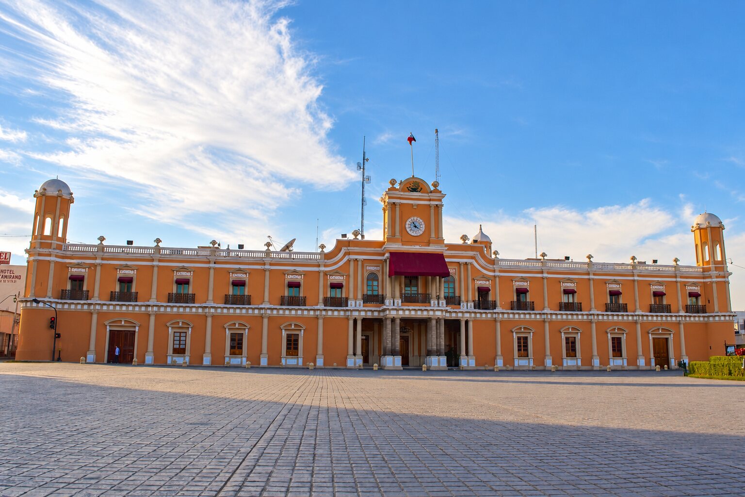
Tepic’s historic center can be walked in a morning. On the Plaza Principal stand the Cathedral of the Immaculate Conception (neo-Gothic, with two slender towers), the City Hall and the arcades with cafés. Two blocks away, the Government Palace holds murals on the history of Nayarit; nearby are the Amado Nervo House Museum (birthplace of the poet), the Regional Museum of Nayarit (shaft-tomb archaeology) and the Museum of the Five Peoples, devoted to Wixárika (Huichol), Cora, Tepehuano, Mexicanero and mestizo art. We mapped the full walk in the historic Tepic route.
Cruz de Zacate temple and Loma de la Cruz
The Temple and Former Convent of the Cruz de Zacate (founded in the 16th century) keeps a cross of grass that, according to tradition, grows without anyone planting it. From there, climb the hill known as Loma de la Cruz, the city’s classic lookout: three crosses on top, views over the valley and the Sangangüey, and trails used by runners and cyclists at dawn.
Parks and urban nature
La Loma Park, with its children’s train and gardens, is the green lung of downtown; the Ecological Park and La Noria Forest are good for walking or jogging. For a different panoramic view, the lookout in the Zitácua neighborhood (a Wixárika community inside the city) shows all of Tepic.
Sangangüey volcano
Sangangüey (2,340 m / 7,677 ft) dominates the skyline southeast of Tepic. The climb is a demanding 5-to-7-hour round trip from the foothills; we explain it step by step in the Sangangüey volcano route.
Santa María del Oro, 45 minutes away
The crater lagoon of Santa María del Oro is 50 km from Tepic. You can swim, paddle and eat fish chicharrón on the shore; it is the most popular day trip from the capital. Read the lagoon that changes color before you go.
If you only have 24 hours, our Tepic in 1 day itinerary arranges all of this into a realistic route.
How to get to Tepic, Nayarit
By plane
Amado Nervo International Airport (TPQ) is 15 minutes from downtown on the road to Xalisco. In 2026 it receives Volaris and Viva flights from Mexico City (both AICM and AIFA), Tijuana, Monterrey and Ciudad Juárez, plus some seasonal U.S. routes. A Mexico City–Tepic flight takes 1 h 20 min and costs from about $1,500–2,500 MXN (80–130 USD) one way when booked in advance. If there is no convenient flight, the alternatives are Puerto Vallarta (PVR), 1 h 45 min away on the new toll highway, and Guadalajara (GDL), 2 h 45 min away on highway 15D. More detail in how to get to Nayarit.
By bus
Tepic’s bus terminal (Central de Autobuses), on Avenida Insurgentes, is served by first-class and luxury lines (Primera Plus, ETN, TAP, Pacífico, Tufesa, Vallarta Plus, among others). Approximate 2026 one-way fares:
| From | Km | Bus time | Approx. fare 2026 | Route |
|---|---|---|---|---|
| Guadalajara | 220 km | 3 h – 3 h 45 min | $350–750 MXN (20–40 USD) | Highway 15D |
| Mexico City | 800 km | 10 – 12 h | $1,000–2,500 MXN (55–135 USD) | 15D via Guadalajara |
| Puerto Vallarta | 170 km | 1 h 45 min – 3 h 30 min | Check fare at the terminal | Jala–Vallarta toll road or Highway 200 |
| Mazatlán | 280 km | 3 h 30 min – 4 h 30 min | $650–900 MXN (35–50 USD) | Highway 15D |
| Monterrey | 1,000 km | 12 – 14 h | Check fare at the terminal | Zacatecas – Guadalajara – 15D |
By car
From Guadalajara, toll highway 15D reaches Tepic in 2 h 45 min with three toll plazas (about $550–650 MXN in total in 2026). From Puerto Vallarta, the Jala–Puerto Vallarta toll road, completed in December 2024, connects to the 15D and puts Tepic 1 h 45 min away; the free federal Highway 200 takes 3 h 30 min. From Mazatlán it is 3 h 30 min on the 15D. Downtown there are public parking lots around the plaza for $20–30 MXN per hour.
What does Tepic mean?
Tepic comes from Nahuatl. The most accepted reading breaks it into tetl (stone) and pic or pictli (solid, hard): “place of solid stones” or “hard hill”, a reference to the volcanic hills around the valley. Another interpretation links it to a short-cycle variety of corn once grown in the area. The name was recorded in colonial times, and the Spanish town founded in 1531 adopted it when it settled beside the original indigenous village.
Tepic weather by season
Thanks to its 915 m elevation, Tepic is cooler and rainier than the coast. Pack a sweater from November to February and an umbrella from July to September.
| Season | Months | Approx. low / high | Rain | What to expect |
|---|---|---|---|---|
| Dry winter | Nov – Feb | 10–12 °C / 27–29 °C (50–54 °F / 81–84 °F) | Very low | Cool mornings, clear skies; best time for downtown and the Sangangüey hike. |
| Warm spring | Mar – May | 13–17 °C / 31–34 °C (55–63 °F / 88–93 °F) | Low | The hottest days of the year; Nayarit State Fair in March. |
| Rainy season | Jun – Sep | 18–20 °C / 29–32 °C (64–68 °F / 84–90 °F) | High (September is the wettest month) | Afternoon storms, everything green; valley and volcano at their most scenic. |
| Transition | Oct | 16–18 °C / 29–31 °C (61–64 °F / 84–88 °F) | Moderate | Rains end; pleasant temperatures. |
Food: what to eat in the capital of Nayarit
At the Juan Escutia and Morelos markets downtown, breakfast costs $70–150 MXN (4–8 USD): blue-corn sopes and gorditas, pozole, stuffed quesadillas, shrimp tostadas and tejuino (a fermented corn drink) with lime sorbet. At night, barbacoa tacos and tortas from stands on the plaza. Forty minutes away, Santa María del Oro serves fish chicharrón and frog legs, and an hour away, San Blas and Mexcaltitán serve the original pescado zarandeado. The full guide is in Nayarit food: 20 traditional dishes.
Distances from Tepic
| Destination | Km | Driving time | Route |
|---|---|---|---|
| Xalisco | 8 km | 15 min | Road to Compostela |
| Amado Nervo Airport (TPQ) | 12 km | 15 min | Road to Xalisco |
| Santa María del Oro (lagoon) | 50 km | 45 min | 15D + state road |
| San Blas | 70 km | 1 h | Tepic–San Blas toll road |
| Jala (Ceboruco volcano) | 80 km | 1 h | 15D |
| Mexcaltitán (boat landing) | 95 km | 1 h 40 min | 15D + Santiago Ixcuintla |
| Sayulita | 130 km | 1 h 45 min | Toll road to Compostela + Highway 200 |
| Puerto Vallarta | 170 km | 1 h 45 min – 3 h 30 min | Jala–Vallarta toll road / Highway 200 |
| Guadalajara | 220 km | 2 h 45 min | Highway 15D |
| Mazatlán | 280 km | 3 h 30 min | Highway 15D |
Frequently asked questions
What is the capital of Nayarit?
The capital of Nayarit is Tepic, a city of 371,387 people (425,924 in the municipality, 2020 census) at 915 m above sea level in the center of the state, between Guadalajara and Mazatlán.
How do you get to Tepic, Nayarit?
By plane to Amado Nervo Airport (TPQ) from Mexico City, Tijuana or Monterrey; by bus from Guadalajara (3 h, about $350–750 MXN), Mexico City (10–12 h) or Mazatlán (4 h); or by car on toll highway 15D. From Puerto Vallarta, the Jala–Vallarta toll road puts it 1 h 45 min away.
What does Tepic mean?
It comes from Nahuatl and is read as “place of solid stones” or “hard hill” (tetl, stone; pictli, solid), after the volcanic hills that surround the valley.
How high is Tepic above sea level?
Tepic is at 915 meters (3,002 feet) above sea level, which explains its cool nights and milder climate compared with the coast.
What is there to do in Tepic in one day?
Walk the historic center (cathedral, Government Palace, Amado Nervo and Five Peoples museums), climb Loma de la Cruz, eat at the market and, in the afternoon, drive to the Santa María del Oro lagoon or visit the Cruz de Zacate temple.
Is Tepic worth visiting?
Yes, especially as a base: it has the state’s best museums, authentic market food, cooler weather than the coast, and San Blas, Santa María del Oro, Jala and Mexcaltitán all within 1 to 2 hours by car.
Area map
- 1Cathedral and main square Historic center of Tepic.21.5119, -104.8913 · Open in Google Maps
- 2Nayarit Regional Museum State archaeology and history (INAH).21.51, -104.8926 · Open in Google Maps
- 3Tepic bus station Buses to Guadalajara, Mexico City, Puerto Vallarta, Mazatlán and the coast.21.4983, -104.8868 · Open in Google Maps
- 4Tepic International Airport (TPQ) Flights to Mexico City and Tijuana; about 15 min from downtown.21.4173, -104.8399 · Open in Google Maps
- 5Sangangüey volcano (summit) Volcano on Tepic's outskirts; a one-day climb.21.4432, -104.7322 · Open in Google Maps